by Doug Thompson
Dr.
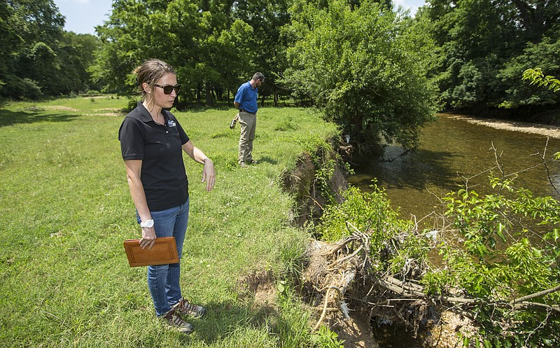
Nicole Hardiman, executive director of the Illinois River Watershed
Partnership, and Bradley Stewart with Springdale Water Utilities look at an
eroded stream bank Wednesday, June 17, 2020, on a forest management property
owned by Springdale Water Utilities. Go to nwaonline.com/photos to see more
photos. (NWA Democrat-Gazette/Ben Goff)
SILOAM
SPRINGS -- Twenty acres of Northwest Arkansas erodes into the Illinois River
and its tributaries every year, people attending a conference on preserving the
river's watershed learned Tuesday.
"Seventy
percent of the inquiries we get from landowners are about stream bank
stabilization," Leif Kindberg, executive director of the Illinois River
Watershed Partnership, told the meeting. The partnership is a nonprofit group
based in Cave Springs and dedicated to improving the quality of the watershed.
Kindberg
was among the speakers at the first public meeting on updating the
watershed-based management plan for the river.
The
erosion problem is worse in Oklahoma, Shannon Phillips, director of the water
quality division of the Oklahoma Conservation Commission, told the meeting. The
watershed begins in Benton and Washington counties, going westward across the
Oklahoma state line and through Tenkiller Lake to the Arkansas River.
Tuesday's
meeting took place at the First Baptist Church in Siloam Springs. About 30
people attended. Plans for more public meetings will be scheduled and announced
by the Natural Resources Division of the Arkansas Department of Agriculture and
the Oklahoma Conservation Commission, representatives of those agencies told
the gathering.
Revising
the watershed management plan is expected to take a year to a year and four
months, Phillips told the group. The watershed management plan draws up goals
and recommendations for voluntary control of "nonpoint source" issues
with water quality, such as erosion, livestock and poultry operations and
stormwater runoff. "Point source" matters, such as wastewater
treatment for cities and industry, are regulated by state agencies, such as the
Arkansas Division of Environmental Quality.
The
20-acre figure derives from erosion studies at 15 different points in the
watershed, Kindberg said. The partnership entered a contract with Natural State
Streams, LLC of Little Rock to study stream bank erosion. Natural State Streams
is a private firm offering environmental consulting and mapping services and
design for erosion control projects.
The
report came out in September 2021, estimating that 102,822 tons of sediment
erode into the river and its tributaries every year. Contributing factors to
the soil loss include higher-than-normal rainfall in recent years, clearing of
trees in the watershed and harder, faster runoff as surfaces are paved or built
over.
An
estimated 54% of the phosphorus released into the upper portion of the
watershed comes from erosion now, according to the study. Phosphorus levels in
the river has been a cause of disagreement between Arkansas and Oklahoma for
years. Phosphorus feeds blooms of algae that cloud the river and harm other
forms of life in it. Efforts at removing chicken litter from the watershed and
other sources have led to a steady drop in phosphorus levels over the years,
but progress has plateaued, Tate Wentz, Water Quality Section Manager for the
Arkansas Natural Resources Division, told the meeting.
One of
the 15 sites selected for monitoring, the worst case, saw almost twice as much
of its banks wash away as the other 14 sites combined, the study reported. The
site involved is about one-half of a mile north of where Arkansas 16 crosses
the Illinois River, near the Savoy community. Measurements and aerial
photography confirm the bank eroded by 135 feet "laterally," or deep,
between May 2019 and and May 2020, the study said.
The dirt
lost from that one site near Savoy from May 2019 to May 2020 amounts to 23,010
cubic yards, according to the study. In other words, enough to fill a sandbox
100 yards long, 50 yards wide and more than four and a half yards deep. The
erosion is so bad that, in the downstream one-third of the river bend there,
"a large number of mature trees are becoming uprooted and entering the
river, causing a significant log jam," the study found.
All
through the watershed, efforts to control erosion or flooding in developed
areas have caused problems in other areas, speakers at Tuesday's meeting said.
For instance, some areas in the floodplain of the river were built up with
enough fill dirt to allow construction, Kindberg said. That prevented the
development from flooding, but hemmed in the flow of water in a nearby creek
bed, increasing the speed and force of water going downstream during and after
storms.
Awareness
of the problems are growing among landowners and cities, speakers said. For
instance, the city of Rogers is encouraging forms of low-impact development
that allow more water to seep into the ground or flow out more slowly, speakers
said.
(Source: https://www.arkansasonline.com/news/2022/oct/16/nwa-losing-20-acres-a-year-to-erosion-in-the/)