by Dartmouth College
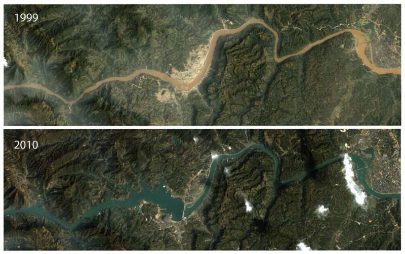
The Three
Gorges Dam dramatically reduced the amount of sediment transported by the
Yangtze River in China after its completion in 2003. The top image shows the
dam site during construction in 1999, when sediment colors the free-flowing
river brown. The bottom image shows the completed dam in 2010. Dark blue water
flows through the dam without sediment, which is trapped upstream in the
reservoir, one of an estimated 50,000 in the river basin. Credit: NASA
Landsat/United States Geologic Survey; Figure: Evan Dethier
The
way rivers function is significantly affected by how much sediment they
transport and where it gets deposited. River sediment—mostly sand, silt, and
clay—plays a critical ecological role, as it provides habitat for organisms
downstream and in estuaries. It is also important for human life, resupplying
nutrients to floodplain agricultural soils, and buffering sea level rise caused
by climate change by delivering sand to deltas and coastlines. However, these
functions are under threat: In the past 40 years, humans have caused
unprecedented, consequential changes to river sediment transport, according to
a new Dartmouth study published in Science.
Using
satellite images from NASA Landsat and digital archives of hydrologic data,
Dartmouth researchers examined changes in how much sediment is carried to the oceans by 414 of the world's
largest rivers from 1984 to 2020.
"Our
results tell a tale of two hemispheres. The north has seen major reductions
in river sediment transport over the
past 40 years, while the south has seen large increases over the same
period," says lead author Evan Dethier, a postdoctoral fellow at
Dartmouth. "Humans have been able to alter the world's biggest rivers at
rates that are unprecedented in the recent geologic record.
"The
amount of sediment rivers carry is generally dictated by natural processes in
watersheds, like how much rain there is or whether there are landslides or
vegetation. We find that direct human activities are overwhelming these natural
processes, and even outweighing the effects of climate change."
The
findings show that massive 20th century dam building in the global hydrologic
north—North America, Europe/Eurasia and Asia—has reduced global in river
suspended sediment delivery to the oceans by 49% relative to pre-dam
conditions. This global reduction has occurred despite major increases in
sediment delivery from the global hydrologic south—South America, Africa and
Oceania. There, sediment transport has
increased on 36% of its rivers in the region due to major land use change.
The
changes to sediment transport in the south have been driven mainly by intensive
land use changes, most of which are associated with deforestation. Notable
examples include logging in Malaysia; alluvial gold mining in South America and
sub-Saharan Africa; sand mining in Bangladesh and India; and palm oil
plantations across much of Oceania. (In prior research,
Dethier found that artisanal gold mining in Peru is associated with increases
in suspended sediment levels).
In
the north, dam building has been the dominant agent of change for rivers in the
past several centuries.
"One
of the motivations for this research has been the global expansion of
building large dams," says
co-author Francis Magilligan, a professor of geography and the Frank J. Reagan
'09 Chair of Policy Studies at Dartmouth, who studies dams and dam removal.
"In the U.S. alone, there are more than 90,000 dams listed in the National
Inventory of Dams." Magilligan says, "One way to think about this is
that we as a nation have been building, on average, one dam per day since the
signing of the Declaration of Independence."
Rivers
are responsible for creating floodplains, sandbars, estuaries, and deltas due
to the sediment that they transport. However, once a dam is installed, that
supply of sediment, including its nutrients, is often shut off.
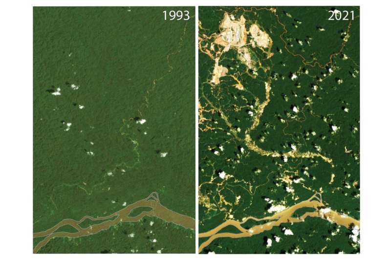
The
Maroni River flows through tropical rainforest along the border of Suriname and
Guyana. Its basin was relatively unaltered until the 1990s. In the past 25
years, major deforestation, mostly by mining operations, has increased erosion
in the basin. The formerly dark brown or blackwater river now carries
additional sediment year-round, even during the dry season. These images from
1993 (left) and 2021 (right) show some of the land use transformation by mining
operations and resulting flow of muddy water into the river. Images: NASA
Landsat/United States Geologic Survey. Figure compiled by Evan Dethier. Credit:
NASA Landsat/United States Geologic Survey; Figure: Evan Dethier
In
the U.S. and other countries in the Northern Hemisphere, however, many dams are
more than a half-century old, and fewer dams are being built in the 21st
century. Recent declines in sediment transport are relatively minimal, as a
result. Dam building in Eurasia and Asia in the past 30 years, especially in
China, has driven ongoing reductions in global sediment transport.
"For
low-lying countries (countries that live at, near or below sea level) in delta
regions, sediment supply from rivers has, in the past, been able to help offset
the effects of sea level rise from
climate change," says Magilligan, "but now you've got the double
drivers of declining sediment from dam construction and rising sea
levels." He says, "This is particularly worrisome for densely
populated places like Vietnam, where sediment supply has been reduced
significantly by dam activity along the Mekong River."
The
results in the north are striking and could foreshadow future changes to come
for the south, as the study reports that there are more than 300 dams planned
for large rivers in South America and Oceania. The Amazon River carries more
sediment than any other river in the world and is a major target for these
dams.
"Rivers
are pretty sensitive indicators of what we're doing to the surface of the
Earth—they are sort of like a thermometer for land use change," says
co-author Carl Renshaw, the Evans Family Distinguished Professor of Earth
Sciences at Dartmouth. "Yet, for rivers in the Northern Hemisphere, dams
are now blocking that signal for sediment coming to the ocean."
Renshaw
says, "It's well-established that there's a soil loss crisis in the U.S.
but we just don't see it in the sediment export record because it's all getting
stuck behind these dams, whereas we can see the signal for rivers in the global
south."
Dethier
says, "In many cases throughout the world, we have built our environment
around rivers and the way that they operate, for use in agriculture, industry,
recreation and tourism, and transportation, but when human activity suddenly
disrupts the way rivers function, it may become difficult to adapt in real-time
to such impacts."
How
dams retain sediment and how land use is increasing downstream erosion are
principles the researchers hope can be used to help inform planning decisions,
and land use and environmental management policies in riparian and coastal
zones in the future.
More
information: Evan N. Dethier et al, Rapid changes to
global river suspended sediment flux by humans, Science (2022). DOI: 10.1126/science.abn7980
Journal
information: Science
(Source: https://phys.org/news/2022-06-world-rivers.html)
Rivers show widespread change from human activity
As rivers flow, they transport suspended sediment, such as sand, silt or clay, which is crucial for downstream ecosystems. The sediment is deposited in places along the way, forming habitats for organisms in the river, as well as in estuaries and deltas. It also supplies nutrients to floodplains where humans till the soil and grow crops, and provides a buffer against sea level rise when it is deposited along coastlines.
Human activities in the past 40 years have drastically changed the amount of river sediment that makes it to the world’s oceans and seas, thereby affecting all of these functions. A new study, led by scientists from Dartmouth College, finds that humans have caused unprecedented, consequential changes to river sediment transport, and to the way that nutrients are cycled into the oceans.
The scientists used NASA Landsat imagery and digital archives of hydrologic data, to estimate changes in how much sediment is carried to the oceans by 414 of the world’s largest rivers. The satellite images covered river hydrology from 1984 to 2020, and field work on the ground delivered over 100,000 measurements to corroborate the estimates.
“Our results tell a tale of two hemispheres. The north has seen major reductions in river sediment transport over the past 40 years, while the south has seen large increases over the same period,” said study lead author Evan Dethier, a post-doctoral fellow at Dartmouth. “Humans have been able to alter the world’s biggest rivers at rates that are unprecedented in the recent geologic record,” Dethier says.
“The amount of sediment rivers carry is generally dictated by natural processes in watersheds, like how much rain there is or whether there are landslides or vegetation. We find that direct human activities are overwhelming these natural processes, and even outweighing the effects of climate change.”
These findings, published in the journal Science, attribute the reduction in river sediment transport in the Northern Hemisphere mostly to 20th century dam building activities. The construction of dams in North America, Europe/Eurasia and Asia has reduced the global delivery of river sediment to the oceans by a massive 49 percent, when compared to pre-dam conditions. This reduction has occurred despite major increases in sediment delivery from Southern Hemisphere rivers.
“One of the motivations for this research has been the global expansion of building large dams,” said study co-author
Francis Magilligan, a professor of geography and the Frank J. Reagan ’09 Chair of Policy Studies at Dartmouth, who studies dams and dam removal. “In the U.S. alone, there are more than
90,000 dams listed in the National Inventory of Dams.”
“One way to think about this is that we, as a nation have been building on average, one dam per day, since the signing of the Declaration of Independence.”
Dam building in the U.S. and Europe has decreased since the start of the 21st century, however, and many of the current dams are more than half-a-century old. Sediment transport by rivers in the U.S. and Europe has declined only minimally in recent decades, as a consequence. However, large dams have been built in Eurasia and Asia in the past 30 years, especially in China, and these new constructions have largely driven ongoing reductions in global sediment transport in the Northern Hemisphere.
Reductions in river sediment flux can have serious consequences for low-lying countries that are at risk from rising sea levels. “For low lying countries (countries that lie at, near or below sea level) in delta regions, sediment supply from rivers has in the past, been able to help offset the effects of sea level rise from climate change,” said Professor Magilligan.
“But now you’ve got the double drivers of declining sediment from dam construction and rising sea levels. This is particularly worrisome for densely populated places like Vietnam, where sediment supply has been reduced significantly by dam activity along the Mekong River.”
By contrast, sediment transport in the global hydrologic south – South America, Africa and Oceania – has increased in 36 percent of the rivers. This situation has been driven by changes in land use, many of which are associated with deforestation and the increase in erosion that results from this practice. Examples of changes in land use around rivers include logging in Malaysia, alluvial gold mining in South America and sub-Saharan Africa, sand mining in Bangladesh and India, and palm oil plantations across much of Oceania.
The researchers found that rivers studied in the global hydrologic south carried suspended sediment at a concentration that was, on average, 41 percent greater now than it was in the 1980s. This north-south divergence has affected global patterns of sediment flux into the oceans, with the dominant sources of river sediment no longer being rivers in Asia, but now being rivers in South America.
Interestingly, this situation could change in the near future as there are more than 300 new dams planed for large rivers in South America and Oceania. The Amazon River carries more sediment than any other river in the world and is a major target for these dams.
“Rivers are pretty sensitive indicators of what we’re doing to the surface of the Earth – they are sort of like a thermometer for land use change,” said study co-author
Carl Renshaw, the Evans Family Distinguished Professor of Earth Sciences at Dartmouth. “Yet, for rivers in the Northern Hemisphere, dams are now blocking that signal for sediment coming to the ocean. It’s well-established that there’s a soil loss crisis in the U.S. but we just don’t see it in the sediment export record because it’s all getting stuck behind these dams, whereas, we can see the signal for rivers in the global south.”
“In many cases throughout the world, we have built our environment around rivers and the way that they operate, for use in agriculture, industry, recreation and tourism, and transportation; but when human activity suddenly disrupts the way rivers function, it may become difficult to adapt in real-time to such impacts,” said Dethier.
—
By Alison Bosman, Earth.com Staff Writer
(Source: https://www.earth.com/news/rivers-show-widespread-change-from-human-activity/)