1 Highlights
●Precipitation is the primary influencing factor of
mean annual runoff depth in the headwater catchments of the Tibetan Plateau,
and temperature is the secondary.
●Precipitation is the primary influencing factor
of sediment yield in the headwater catchments of the Tibetan Plateau, and
glacier area ratio is the secondary.
●The
variation of sediment yield in the arid and semi-arid headwater catchments
is dominated by vegetation protection action, while in semi
humid catchments it is mainly related to rainfall erosive action.
2 Article information
Zhang, F., Zeng, C., Wang, G., Wang, L., Shi, X. (2022). Runoff and
sediment yield in relation to precipitation, temperature and glaciers on the
Tibetan Plateau. International Soil and Water Conservation Research, 10(2),
197-207.
DOI: 10.1016/j.iswcr.2021.09.004
3 Article Introduction
Sediment yield reflects the total amount of
sediment generated within the catchment and delivered to the river outlet over
a particular timeframe. The magnitude of the sediment yield is considered as an
important measure of land degradation and loss of soil nutrients in river
catchments. The Tibetan Plateau, as the headwaters of more than ten major
rivers of Asia, is called the Asian Water Towers. It has experienced dramatic
environmental changes such as rapid warming accompanied with glacier melt
enhancement and water cycle intensification over the past five decades. Soil
erosion and sediment transport dynamics in alpine environments such as the
Tibetan Plateau differ from those of the lowlands in many aspects, such as
impacts of the glaciers and other cryosphere components. With the growth of
interest in environmental change in the alpine regions such as the Tibetan
Plateau and better predicting the effect of glacier retreat on sediment
transport changes, it is important to study the characteristics of runoff and
sediment yields and identify the dominant factors. This study investigated mean annual runoff
depth and sediment yield from eight headwater catchments in relation to annual
precipitation, air temperature, and glacier area ratio, etc., and aimed to
identify the dominating climatic and cryospheric factors, reveal the potential
mechanism of the gross variations in runoff and sediment load in response to
the variations of the dominating factors; and characterize the particularity of
runoff generation and sediment transport processes in alpine regions with
glaciers.
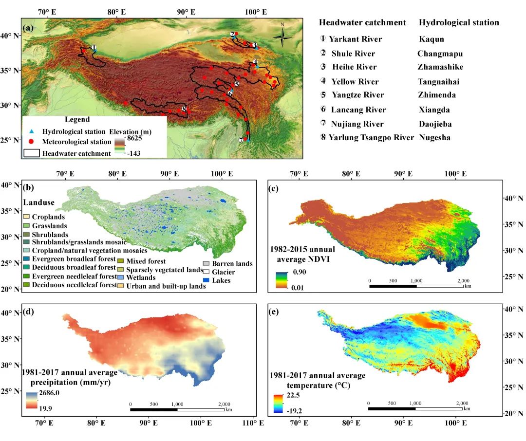
图1 青藏高原8个江河源流域:叶儿羌河(YKR,卡群站以上)、疏勒河(SR,昌马堡站以上)、黑河(HR,扎马什克站以上)、黄河(YR,唐乃亥站以上)、长江(YZR,直门达站以上)、澜沧江(LR,香达站以上)、怒江(NR,道街坝站以上)、雅鲁藏布江(YTR,奴各沙站以上)(a),土地利用(b),NDVI(c),年均降水量(d),年均气温(e)。
Fig. 1 The headwater catchments of the
Yarkant River (YKR), Shule River (SR), Heihe River (HR), Yellow River (YR),
Yangtze River (YZR), Lancang River (LR), Nujiang River (NR), and Yarlung
Tsangpo River (YTR) on the Tibetan Plateau with outlet hydrological stations
located at Kaqun, Changmapu, Zhamashike, Tangnaihai, Zhimenda, Xiangda,
Daojieba, and Nugesha, respectively (a), land use (b), mean NDVI (c), mean
annual precipitation (d) and mean air temperature (e).
● MLR analysis shows that precipitation is the primary influencing
factor of mean annual runoff depth in the eight headwater catchments of
the Tibetan Plateau, and temperature is the secondary. For the individual headwater catchment,
the regression coefficient of precipitation (a in the regression equation
Q = aP+bT+c) are constantly positive (Fig. 2), while the regression
coefficients of temperature (b in the regression equation) are
positive for catchments with larger glacier ratios, i.e., the annual runoff is
positively correlated with the annual mean air temperature (Fig. 3), indicating
the stronger increase in melt water supply caused by warming than evaporation
loss in these catchments; in contrast, the temperature coefficients tend to be
negative for catchments with smaller glacier area ratios (Fig. 3), i.e., the
annual runoff is negatively correlated with the annual mean temperature,
suggesting the stronger evaporation loss caused by warming than melt water
supply. For the eight headwater catchments, the coefficients of
precipitation and air temperature in the regression equation Q = 0.357×P +
20.3×T ? 6.4(R2=0.94)are both positively correlated with annual runoff
indicate that meltwater supply in general is greater than the evaporation loss
caused by temperature increase in the alpine regions with glaciers, such as the
eight headwater catchments on the Tibetan Plateau investigated in this study.
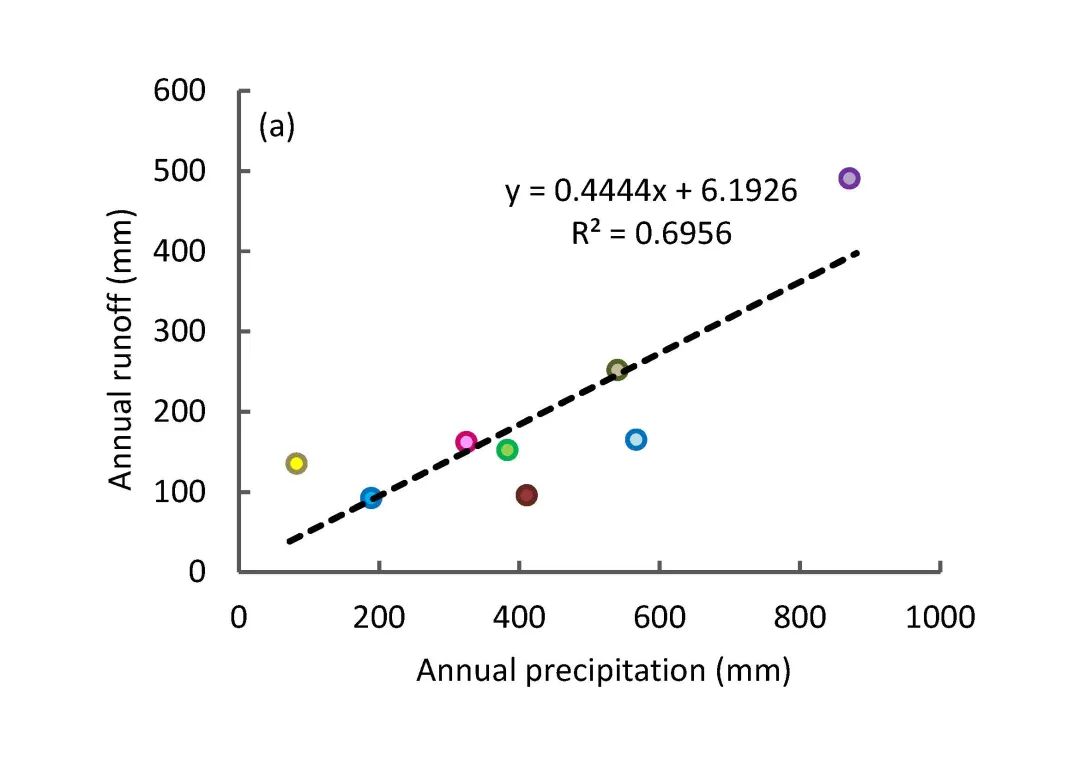
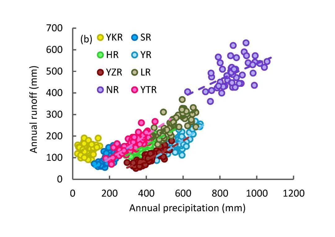
图2 8个江河源流域多年平均降水和径流深的关系
Fig. 2 Relation between annual
precipitation and runoff of the eight headwater catchments.
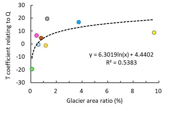
图3 8个江河源流域与径流相关的气温系数与冰川面积占比间的关系
Fig.3 The relationship between coefficient
of air temperature (T coefficient) relating to runoff and glacier area ratio of
the eight headwater catchments.
● MLR analysis also shows that precipitation is the primary influencing
factor of sediment yield in the headwater catchments of the Tibetan Plateau,
and glacier area ratio is the secondary. Fig. 4 shows an inverted parabolic relationship
between mean annual precipitation and sediment yield of the eight headwater
catchments. Mean annual sediment yield reach a minimum value at about 500-600
mm of mean annual precipitation, increasing sharply on both sides of this
minimum. The MLR equation for mean annual sediment yield (S) with mean annual
precipitation (P) and glacier area ratio (Ag) is S = 0.000609×P2 –
0.470×P + 48.5×Ag + 202.53 with a high R2 value
of 0.89.It is shown that, in addition to the leading contribution of
precipitation, the sediment yield is positively related to glacier area ratio
in the alpine catchments with glaciers, indicating a higher erosion rate in glacierized area
than that in non-glacierized area.
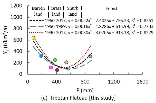
图4 8个江河源流域输沙量与年均降水量的关系
Fig. 4 Relation of sediment yield to
annual precipitation in the eight headwater catchments.
● The variation of sediment yield in the
arid and semiarid headwater catchments is dominated by vegetation
protection action, while in semi-humid catchments is mainly related to rainfall
erosive action. The variation in
sediment yield with precipitation can be explained by the operation of two
factors, i.e., the factor of rainfall erosive action and factor of vegetation
protective action, and can be represented by mathematical expression in the
following form (Langbein and Schumm, 1958) S=aPm/(l+bPn)
where the factor aPm in the equation is considered as the
factor of rainfall erosive action and the die-away factor 1/(l+bPn)
is considered as the factor of vegetation protective action. According to Fig.
4 and Fig. 5, the
direction of a change in sediment yield in the headwater catchments of the
Tibetan Plateau with changing precipitation appears to be dependent on the
amount of precipitation. i.e., resulting in a decrease in erosion
with increasing precipitation owning to a rapid increase in the factor of
vegetation protective action (Fig. 5b and 6) in the region with mean annual
precipitation less than 500 mm, but an increase in erosion with increasing
precipitation owing to an increase in the factor of rainfall erosive action in
the region with mean annual precipitation higher than 600 mm.
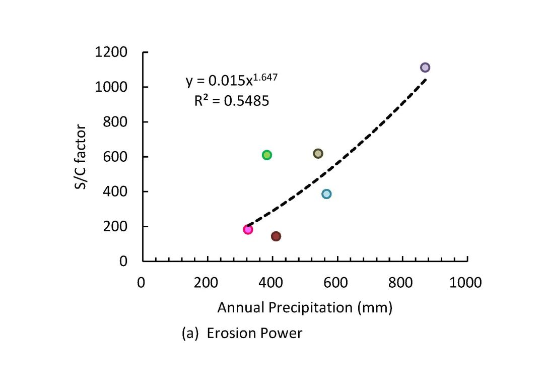
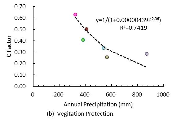
图5 青藏高原主要江河源流域降雨侵蚀作用因子和植被保护作用因子与年降水量之间的关系。
Fig. 5 Relation of factor of rainfall
erosive action (a) and factor of vegetation protective action (b) to annual
precipitation in the headwater catchments of the Tibetan Plateau excluding two
catchments with maximum glacier area ratios.
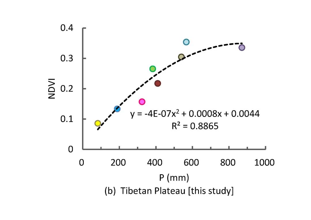
图6 高原8个江河源流域NDVI和年降水量之间的关系
Fig. 6 Relation of NDVI to annual
precipitation in the eight headwater catchments of the
Tibetan Plateau
4 About the authors

曾辰,中国科学院青藏高原研究所助理研究员,主要研究方向为高寒区水文和侵蚀输沙
联系方式:zengchen@itpcas.ac.cn
Zeng Chen, Assistant
Professor of Institute of Tibetan Plateau Research, Chinese Academy of
Sciences, mainly focuses on hydrology, erosion and sediment transport in alpine
regions.
Contact information: zengchen@itpcas.ac.cn

张凡,中国科学院青藏高原研究所研究员,主要研究方向为青藏高原水沙及水环境
联系方式:zhangfan@itpcas.ac.cn
Zhang Fan, Professor
of Institute of Tibetan Plateau Research, Chinese Academy of Sciences, mainly
focuses on water flow, sediment, and reactive transport in the Tibetan Plateau.
Contact information: zhangfan@itpcas.ac.cn
图 高寒流域
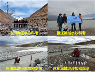
图 高寒流域水沙野外科考与加密观测
中国科学院青藏高原研究所张凡研究员带领的青藏高原水沙及水环境研究小组主要关注青藏高原江河源区侵蚀输沙过程与机理研究以及模型开发。研究小组目前有14人(研究员1名、副研1名、助研1名、博士后2名、研究生9名),在青藏高原的黑河流域、雅鲁藏布江流域以及长江源等多个高寒流域建立了水-沙-水环境综合监测体系,开展了高寒区冰川流域水沙过程长期监测与侵蚀输沙理论研究。
5 Keywords
高寒流域;气候条件;冰川侵蚀;径流量;输沙模数
Alpine catchment; Climate condition; Glacier erosion;
Runoff; Sediment yield
6 Relevant research recommendations
Shi, X. , Zhang, F. , Wang, L. , Jagirani,
M. , Zeng, C. , Xiao, X. , Wang, G.(2020).Experimental study on the effects of
multiple factors on spring meltwater erosion on an alpine meadow slope.
International Soil and Water Conservation Research, 8(2), 116-123.
https://doi.org/10.1016/j.iswcr.2020.02.001
Gwapedza, D. , Nyamela, N. , Hughes, D.A. ,
Slaughter, A.R. , Mantel, S.K. , Waal, B. (2021).Prediction of sediment yield
of the Inxu River catchment (South Africa) using the MUSLE. International Soil
and Water Conservation Research, 9(1), 37-48.
https://doi.org/10.1016/j.iswcr.2020.10.003
Duan, X. , Deng, Y. , Tao, Y. , He, Y. ,
Lin, L. , & Chen, J. (2021).The soil configuration on granite
residuals affects Benggang erosion by altering the soil water regime on the
slope. International Soil and Water Conservation Research, 9(3), 419-432.
https://doi.org/10.1016/j.iswcr.2021.03.003
Zheng, H. , Miao, C. , Zhang, G. , Li, X. ,
Wang, S. , Wu, J. , Gou, J.(2021).Is the runoff coefficient increasing or
decreasing after ecological restoration on China’s Loess Plateau?.
International Soil and Water Conservation Research, 9(3), 333-343.
https://doi.org/10.1016/j.iswcr.2021.04.009
Zhou, Y. , Zhang, B. , Qin, W. , Deng, Q. ,
Luo, J. , Liu, H. , Yang, D. , Wang, H. ,Zhao, Y. (2021).Primary
environmental factors controlling gully distribution at the local and regional
scale: An example from Northeastern China. International Soil and Water
Conservation Research, 9(1), 58-68.
https://doi.org/10.1016/j.iswcr.2020.08.004
青藏高原江河源区径流量和输沙量与降水量、气温和冰川的关系
原创 ISWCR编辑部 国际水土保持研究ISWCR 2022-04-13 09:30
ISWCR 编委、中国科学院青藏高原研究所张凡研究员在ISWCR发表其研究团队最新成果。该研究分析了青藏高原8个主要江河源区年均径流量和输沙量与降水量、气温和冰川占比间的关系,确定了影响径流和输沙的主导因子,揭示了径流和输沙变化对主导因子变化的响应机制,并明确了高海拔冰川流域产流和输沙过程的特殊性。
1文章要点(Highlights)
●降水是江河源区多年平均径流深的最主要影响因素,其次是气温
Precipitation is the primary influencing factor of
mean annual runoff depth in the headwater catchments of the Tibetan Plateau,
and temperature is the secondary.
●降水是江河源区输沙模数的最主要影响因素,其次是冰川面积占比
Precipitation is the primary influencing factor
of sediment yield in the headwater catchments of the Tibetan Plateau, and
glacier area ratio is the secondary.
●干旱、半干旱江河源区输沙变化受植被保护作用主导,半湿润江河源区受降雨侵蚀力主导
The
variation of sediment yield in the arid and semi-arid headwater catchments
is dominated by vegetation protection action, while in semi
humid catchments it is mainly related to rainfall erosive action.
2文章信息(Article information)
Zhang, F., Zeng, C., Wang, G., Wang, L., Shi, X. (2022). Runoff and
sediment yield in relation to precipitation, temperature and glaciers on the
Tibetan Plateau. International Soil and Water Conservation Research, 10(2),
197-207.
DOI: 10.1016/j.iswcr.2021.09.004
Download PDF
3 文章导读(Article Introduction)
输沙量反映了特定时段内流域内产生的泥沙输移到流域出口断面的总量,是衡量流域土地退化和养分流失的重要指标。被誉为“亚洲水塔”的青藏高原是亚洲十多条大江大河的发源地。过去五十年间青藏高原经历了剧烈的环境变化,例如快速升温、冰川融水增加和水循环加剧等。受冰川等冰冻圈要素的影响,青藏高原高寒环境下的土壤侵蚀和输沙动力过程与低海拔区域相比有许多不同之处。随着对青藏高原等高寒地区环境变化以及更好地预测冰川退缩对输沙变化的影响等研究需求的增加,确定高寒区径流和输沙特征、识别其主导因素等相关研究十分重要。本研究分析了青藏高原8个主要江河源区年均径流深和输沙模数与降水量、气温和冰川占比间的关系,旨在确定影响径流和输沙的主导气候因子和冰冻圈因子,揭示径流和输沙变化对主导因子变化的响应机制,明确高海拔冰川流域产流和输沙过程的特殊性。
(Source: International Soil and Water Conservation Research)